DUNSINK DEVELOPMENT: THE IMPACT ON CASTLEKNOCK
It’s important that in trying to solve one crisis that we don’t create another.
The Dunsink Urban Area Plan has the potential to deliver much-needed housing, but it must be properly planned. The proposed Dunsink Urban Area Plan will create a major new town close to Castleknock. With a population the same size as Castleknock the Dunsink Development will be the biggest development in Fingals history and it will have a significant impact on Castleknock. It is important that it planned to help ease a housing crisis and not create another Ballymun.
Dunsink is located between Finglas, Ashtown, Castleknock and Blanchardstown. Although the Dunsink development covers 435 hectares, only 102 hectares are designated as net residential land — just under a quarter of the entire site. This excludes land reserved for schools, parks, commercial facilities and community uses. The net residential area is roughly equivalent to a square measuring one kilometre by one kilometre.
High-Density Development
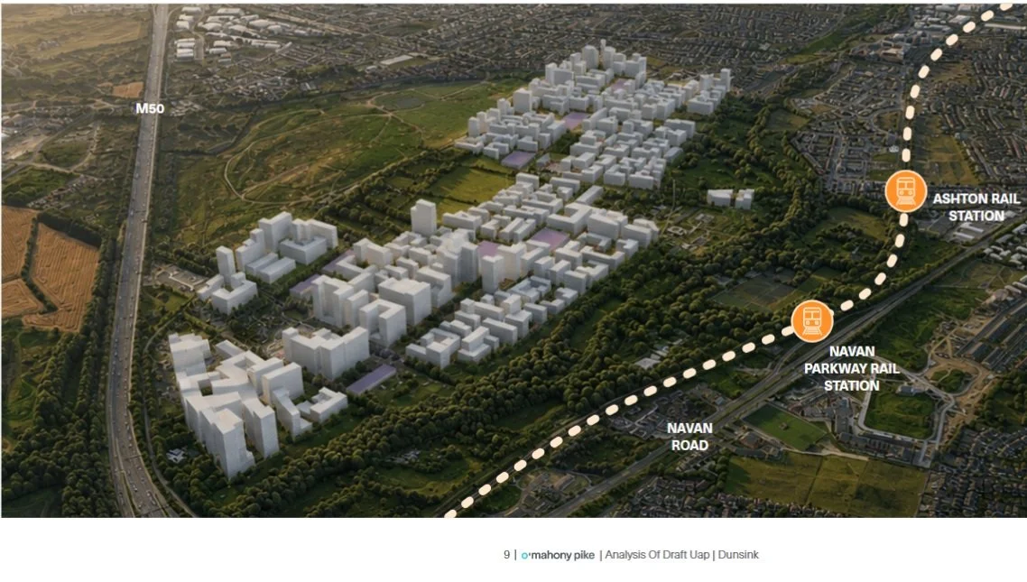
Dunsink has the potential to create 15,000 high-density homes, the majority of which are expected to be apartments. With a potential population of 37,500 people in an area of approximately 1km by 1km, what will the impact be on Castleknock and the surrounding communities? The Dunsink development must provide a genuine mix of homes for people at different stages of life, alongside facilities that support social inclusion and community participation.
The current plan proposes densities of 60–150 dwellings per hectare. These are high densities, particularly at the upper end of the range, and raise questions about the balance between housing numbers, building heights, green space and the provision of essential services. The governments own guidelines are 40-80 dwellings per hectare.
The scale of the development could dramatically change the landscape around Castleknock. Large apartment blocks and intensive development close to established residential areas raise concerns about residential amenity, visual impact and the transition between existing neighbourhoods and the new urban settlement.
Traffic and Road Safety
A development of this scale will generate substantial additional travel. Castleknock residents will experience increased pressure on connecting roads and busy junctions as the population of Dunsink grows.
The Navan Road, New River Road and Auburn Avenue junction, along with other routes serving Castleknock and will be impacted and must be properly assessed for the cumulative impact of the proposed development. The Dunsink Urban Area plan notes that “the existing road network is limited in capacity and faces significant challenges in accommodating additional traffic generated by future development” and that the “area already has significant delays, notably at the M50 Junction 6 (M50/N3 Interchange)”. The current plan relies on the existing road network to provide access to the new Dunsink development.
Schools, Healthcare and Public Services
15,000 homes could bring approximately 37,500 additional residents to Dunsink. This will create significant demand for school places, childcare, GPs, healthcare, Garda services and community facilities.
Existing services in Castleknock cannot automatically be assumed to have the capacity to accommodate this growth simply because they are nearby. Thousands of additional residents will need suitable school places. There are plots of land in the plan set aside for schools but the Department of Education, not Fingal County Council, is responsible for providing school accommodation.
A major new community should not depend on existing services absorbing additional demand without the necessary funding, facilities and staff.
Infrastructure Must Come First
The Dunsink development raises serious questions about water infrastructure and the risk of housing delivery outpacing essential services. The Shannon-to-Dublin water supply project, a major infrastructure scheme estimated to cost between €7.3billion has not yet commenced construction and remains subject to planning approval. This waterpipe is needed to complete the development and it would leave the development half finished if there are delays.
Castleknock and the surrounding communities must not be left dealing with the consequences of a half-finished development because essential infrastructure has failed to keep pace with housing delivery.
Transport Must Be Realistic
The high density development relies on transport improvements, including a potential future Luas extension. The Dunsink Plan places excessive reliance on the delivery of Luas Tyrrelstown after 2042, despite the scheme remaining at an early stage, with planning yet to commence and its final alignment still undetermined. The Plan assumes a level of certainty around its delivery and timing that is not currently justified.
A development of this scale should not depend on a transport project that has not yet entered the planning process. The plan must demonstrate how Dunsink can be adequately served by transport infrastructure that is deliverable, funded and operational in line with the phased delivery of housing.
JUNCTION 6, M50
Dunsink is one of the biggest developments in Fingal County Councils history. This new town will join the M50 interchange at Junction 6 from the Navan Road. There are questions to be answered to see if the road network accommodate the additional traffic generated by a development of this scale. Fingal County Council need to consider bridges across or under the M50 to accommodate the volume of traffic that will be generated by this development.
A Responsible Plan for Castleknock and Dunsink
Castleknock residents deserve clear answers about how a development of this scale will affect local roads, public transport, schools, healthcare, green spaces and community facilities.
We support housing. We support responsible development. But a development of this scale must be planned around the needs of people, not simply the number of homes that can be built.
Castleknock must not be left to absorb the consequences of high-density development without the transport, infrastructure, services and investment needed to support both existing and future communities.
THE BIGGER PICTURE
The image below was generated by O'Mahony Pike Architects as part of the Dunsink Urban Area Plan Consultation to give people an indication of the scale of this development.
HOUSING MUST BE MATCHED BY INFRASTRUCTURE — NOT FOLLOWED BY YEARS OF CONGESTION AND OVERSTRETCHED SERVICES.