FINGLAS, CABRA, ASHTOWN AND CASTLEKNOCK SUPPORTS HOUSING
We Support Housing. We Want Better Planning.
It’s important that in trying to solve one crisis that we don’t create another.
The Dunsink Urban Area Plan has the potential to deliver much-needed housing, but it must be properly planned. Dunsink will be nearly the same population as Finglas and it’s important that it is planned to help ease a housing crisis and not create another Ballymun.
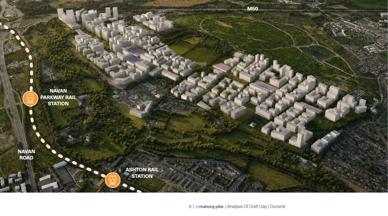
Dunsink is located between Finglas, Ashtown, Castleknock and Blanchardstown. Although the Dunsink development covers 435 hectares, only 102 hectares are designated as net residential land — just under a quarter of the entire site. This excludes land reserved for schools, parks, commercial facilities and community uses. The net residential area is roughly equivalent to a square measuring one kilometre by one kilometre.
1. Infrastructure First and Binding
No phase of development should proceed until the necessary water, transport and school infrastructure is in place. There must be no exceptions that allow homes to be occupied before essential services are ready. Ireland has been flooded with bad developments that promised necessary infrastructure in glossy brochures but that have never materialised. As this development will have the population of 37,500 it is essential that the infrastructure has been secured before the development is built.
Road access must also be carefully planned as this plan relies on the current road structures. Currently the Ratoath Road, Auburn Avenue, Dunsink Lane, Junction 6 M50 and the Navan Road will carry the burden of all the traffic generated from Dunsink. There needs to be appropriate measures to protect Dunsinea Lane and Scribblestown Lane from unnecessary damage and destruction.
2. Create Densities That Match Public Transport Capacity
Housing densities must reflect the public transport infrastructure that is actually committed and deliverable, not projects that remain uncertain or are many years away. The densities currently planned are way in excess of governments guidelines and they should be brought down to 40-80 densities per hectere.
The plan should not rely on a Luas extension currently indicated as a post-2042 project (which isn’t currently funded) to justify higher densities today. Development must be proportionate to existing and realistically planned transport capacity.
3. Properly Assess the Former Dunsink Landfill
Independent environmental testing of the former Dunsink landfill is essential to establish whether the proposed development can proceed safely. It is essential that all of the illegal dumps surrounding the main landfill are independently tested.
The assessment must identify potential contamination risks and demonstrate that the land is suitable for its intended use, protecting both future residents and existing communities. Development decisions must be informed by reliable evidence and appropriate safeguards.
4. Protect Habitats and Biodiversity
Scribblestown Lane, Dunsinea Lane and Tolka Valley Park are valuable natural assets that must be protected and enhanced. Tolka Valley Park is the third most biodiverse park in Dublin and Scribblestown Lane and Dunsinea Lane are important biodiversity corridors.
The plan must safeguard mature hedgerows, trees, wildlife habitats and biodiversity corridors. These features support local wildlife, contribute to the area's character and provide important green space for surrounding communities. They are the lungs that protect the surrounding communities from the pollution from the M50 and the clogged local roads.
Environmental protection must be built into the development from the outset, rather than treated as an afterthought.
5. Plan Jointly with Dublin City Council
The impacts of the Dunsink development will extend beyond the county boundary, affecting neighbouring communities and transport networks.
Fingal County Council and Dublin City Council must work together on traffic management, transport, infrastructure and public services. We are calling for a joint committee to coordinate planning and ensure that the wider impacts on surrounding communities are properly addressed.
A Proper and Transparent Planning Process
Alongside these five changes, we are calling for a meaningful consultation process, proper testing of alternative development densities, a 3D model showing what is proposed, and a clear breakdown of the associated costs.
Residents must be able to understand the proposals, assess their likely impacts and have a genuine opportunity to influence the outcome.
Our Message
We support the delivery of much-needed housing. The development must be safe, sustainable and fair to the communities who will live with its consequences.
Infrastructure must come first. Densities must be realistic. The landfill must be independently assessed. Biodiversity must be protected. And planning must be coordinated across county boundaries.
These changes are essential to delivering a Dunsink development that works for new residents and existing communities alike.
The 3D image below of Dunsink was created by O’Mahony Pike Architects